Elevated transport infrastructure don’t get no love.
Architects and urban designers decry their ugliness and their ability to rip apart neighbourhoods and very few people are willing to step up and argue against that point.
But to prove that elevated infrastructure isn’t always the city killer critics claim, we asked readers of The Gondola Project to help us come up with a list of the 10 most beautiful examples of elevated transport infrastructure around the world.
To make this list we didn’t consider any standard transit metrics like speed, reliability and capacity. We also didn’t consider the view the various systems afforded their riders. All we considered were the aesthetics of the systems as they interact with the urban fabric that surrounds them.
Note: This list is highly unscientific and prone to gross subjectivity. Feel free to argue about them all you want. This list isn’t about science, it’s about inspiration. Hopefully, this list can help people imagine a world where elevated infrastructure doesn’t destroy the urban form, but actively contributes to it instead.
This is Part 1 of 2.
10. The Schwebebahn – Wuppertal, Germany

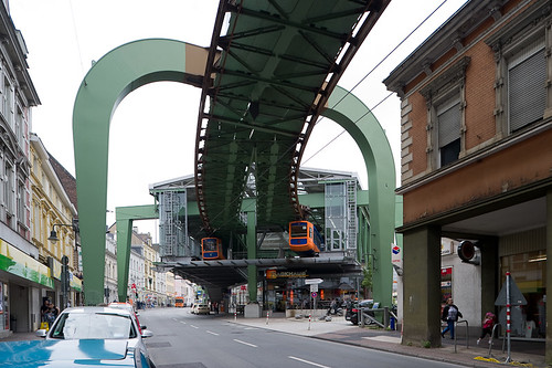
The Wuppertal Schwebebahn as it cuts through downtown overtop the Wuppertal River. Image by flickr user Glyn Lowe.
Starting a list about the most beautiful elevated transit infrastructure in the world with the Wuppertal Schwebebahn is like starting a kosher meal with a bacon appetizer. Something just doesn’t look right.
To be frank, one could argue that the Schwebebahn shouldn’t even be on this list. It’s big, it’s old and it’s imposing. But by virtue of the sheer number of nominations it received, we felt we had to include it. For some reason, people love the steampunk transit relic from Wuppertal, Germany.
This 13 km long monorail (the world’s oldest) does something no other rail-based transit system has ever done – it uses a river corridor as a transit artery. Rather than moving alongside the river as other systems have done, the Schwebebahn glides above the river Wupper. There is something both picturesque and hauntingly gothic about the experience all at the same time. You’re aware both of the gentle river below and the cast-iron-and-rivet support columns whipping by the window, reminding you of some bygone Dickensian industrial era.
And while riding the Schwebebahn is unlike any transit experience you’re likely to encounter, when the system enters the urban environment proper, it quickly overwhelms the streetscape below it. The Schwebebahn snakes between buildings and darts above intersections with a degree of efficiency rarely seen in public transit, but the infrastructure encloses all around it. And that’s its great failure.
It’s a fascinating system to take in but is a product of a time where nature and city were not things to be at ease with – they were things to be confronted, tamed and conquered.
Really and truly, the Wuppertal Schwebebahn is what transit would have been in Gotham City had Batman lost his drivers license and been forced to buy a Metropass. Or at least that’s the impression I received while riding it in the rain at night.
It may not be beautiful, but it’s something to behold. As strange and ugly a system as it is, it all somehow works. Notwithstanding the obvious colour comparisons, the Schwebebahn reminds one of The Green Monster in Boston’s Fenway Park. Both are beloved but ugly. There’s nothing particularly attractive about either of them, but a practical attachment to history have made each an indelible part of their local cultures.
The Schwebebahn was also the site of the Tuffi the Elephant incident which all but assured the system’s place on this list – you can read up on that one yourselves.
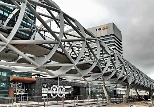
9. The Randstadrail – The Netherlands
A couple of weeks ago, we wrote a post on the Randstadrail in The Netherlands. That post was sort of the genesis behind this entire list.
You can find that post here.
8. Gürtelviadukt – Vienna, Austria
Designed by architect Otto Wagner and built in the 1890’s, Vienna’s Stadtbahn was a response to rapid population growth in the Austrian capital. But like many rail schemes of the era, parts of the line were built on large elevated viaducts meant to pierce the city and avoid all at-grade traffic.
The most famous of these viaducts was the Gürtelviadukt running alongside the important Gürtelstrasse ring road.
Like many such rail corridors, the elevated Gürtelviadukt portion of the Stadtbahn was excellent at moving people and goods but had the unintended effect of dividing the city into parts. Where it intersected with the Danube River Canal, it created a virtual wall between the city and its riverfront.
Despite the harmful effects it had on Vienna’s urban fabric, it remained an essential transportation link. And while many of Otto Wagner’s original buildings and designs were destroyed in the 40’s and 50’s, those elevated portions that remain are protected under heritage preservation laws due to their historical importance as examples of early Art Nouveau architecture. The Gürtelviadukt, meanwhile, is still used as the U6 line of Vienna’s U-Bahn light rail system.
Over time, however, the Gürtelviadukt has become fully-integrated into the city’s fabric. While respecting the heritage of Otto Wagner’s original design, the arched bays are now filled with shops, restaurants and clubs creating a direct link between the viaduct and pedestrian traffic. Meanwhile, along the Donaukanal site, the viaduct has been re-imagined as the Spittelau Viadukt, an innovative housing project by British architect Zaha Hadid.
The Spittelau Viadukt complex comprises 3 buildings of apartments, offices and studios that twist and turn over, under and through the original viaduct. The buildings are arresting and their contemporary forms sit in stark contrast to Wagner’s original plans. They do, however, prove that the modern urban environment can adapt to and even co-exist with elevated transport infrastructure from years gone by.
7. The City Center Tram – Las Vegas, Nevada
The City Center Tram in Las Vegas is one of two recent Cable Propelled Transit systems to grace the Las Vegas Strip, the other being the Mandalay Bay Cable Car. Both are Cable Liner Shuttles designed and installed by Doppelmayr Cable Car – neither are transit systems in a standard sense.
Both are privately built systems that exist to shuttle hotel tourists and employees from one resort to another. Their purpose is to keep tourists within the confines of their respective MGM resort properties, not to transport people around the city to other competing casinos. While there may only be three stations, the City Centre Tram does create an easy link between City Center and MGM’s Monte Carlo property to the south and its Bellagio property to the north.
But connectivity isn’t the reason this system makes this list. The City Center Tram appears here because of the way that it is seamlessly integrated with the surrounding buildings and urban fabric.
City Center was the single largest private development in United States history. During the economic boom, Vegas was one of the fastest growing cities in the United States and City Center was to be it’s new downtown. It was to be a condo-hotel-shopping-complex that would anchor the Las Vegas Strip in a way it had never been anchored before – hence the name “City Center.”
But with the collapse of the economy in 2008, City Center quickly became a white elephant that still hasn’t quite recovered. Like much of Vegas right now, it’s a bit of a ghost town. Nevertheless, the architecture and planning is all starchitects, Gucci, glass and steel. It screams this is the future, behold!
The City Center Tram only reinforces that image.
Most often public transport infrastructure is grafted onto an existing urban form, oftentimes disrupting said form. In the case of elevated infrastructure, that problem is only compounded. Oftentimes the incursion of elevated infrastructure can create massive conflicts between uses and disturb the urban fabric to an almost cataclysmic degree. Not so with the City Center Tram.
Because the tram was designed in tandem with City Center itself there is never a conflict between the two. Each compliment one another wonderfully. End-stations are cleverly located atop canopied roofs and the intermediary station is located inside the Daniel Libeskind-designed Crystals shopping center.
As you ride the City Center Tram, you’re immediately taken in by the future-quality of it all. Inside and outside blend together into a continuous steel jungle. Everything is up and automated and quick.
Wandering around City Center, the elevated cable cars provide needed animation to the spaces between buildings, while the system’s modular steel beam guideways reinforce the point that infrastructure and architecture can oftentimes go hand-in-hand.
It may not be a large system, but it’s a system chock-full of lessons.
6. Ligne 6, Metro – Paris, France
Most probably don’t know this, but much of the famed Paris Underground was originally planned as an elevated system criss-crossing the city. That’s right: The Underground was never meant to be underground. Yet even 130 years ago, aesthetic concerns prevailed and the system eventually was placed underground.
(For a fairly in-depth history of the early stage planning of the Paris Metro check out Mark Ovenden’s Paris Underground).
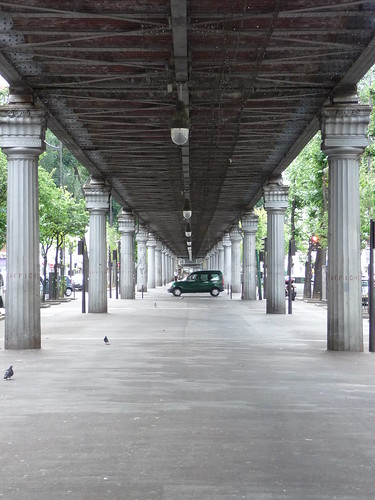
Nevertheless, much of Ligne 6 (originally Ligne 2 Sud) of the Paris Metro is located above ground. Roughly half the line’s 13 kms is situated atop viaducts located in boulevards that once occupied city walls and on bridges that cross the Seine.
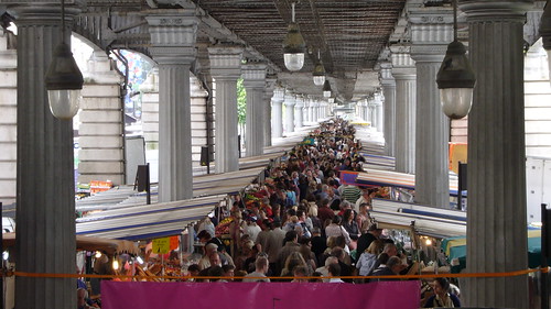
These viaducts privilege form as much as function and allow for some of the most spectacular views of Paris. Areas beneath the viaducts are reserved for pedestrians, bikes and market stalls.
Too much elevated infrastructure throughout the world is treated purely as function with no care as to what happens below it. Not here.
Areas below the viaducts are places for people and are adorned as such: Ionic columns and stone arches replace standard support structures to create architectural spaces that are intentional and planned.
Granted you couldn’t do this everywhere. To do elevated infrastructure in the way done here, one requires a wide road berth. And one of the reasons for Ligne 6’s success is that much of it is located in the middle of the impossibly wide Boulevard Auguste-Blanqui.
At over 70 meters wide, Boulevard Auguste-Blanqui can accommodate such a structure in ways that most dense European cities never could. At the same time, many new suburban arterial roads throughout the world are even wider. Yet when newer elevated infrastructure is built we wind up with things like Toronto’s Gardiner Expressway and the elevated portions of New York’s subway system – structures that are utilitarian at best. Calling them ‘ugly’ is a compliment.
The point is this: The elevated portions of Ligne 6 are proof positive that given the right environment, elevated transit infrastructure does not have to divide a city and can contribute to the urban form.
Moreso, it is a clear demonstration of how architects and urban designers can actually work with elevated forms of transit rather than simply fear and ignore them.


10 Comments
“All we considered were the aesthetics of the systems as they interact with the urban fabric that surrounds them.”
Though the Schwebebahn and the City Center Tram made it into the list of most beautiful examples of elevated transport infrastructure.
In that case I’d say a lot of bridges are more beautiful than those 2.
Besides: the importance of the Schwebebahn I do understand in that list, but I strictly have to disagree with the one in Las Vegas. Well, my strange replacement would be The Great Wall.
So, I can’t wait to see the first part of that list and maybe go on talking about that list tomorrow.
Suggestion, maybe a little hard: what about the ugliest elevated transport infrastructure?
@ LX,
True enough. The Schwebebahn is ugly, but enough people suggested it I felt it important to listen to the readers.
As for the City Center Tram I do believe strongly that it belongs on the list. Maybe you have to experience it first-hand, but the way the system works with the surrounding city scape and architecture is stunning! It’s also one of the only contemporary examples.
And while I agree with you about the whole “bridge” issue, bridges don’t impact the urban fabric anywhere near as much as elevated transport infrastructure does. The point of this post was to deal with that issue and the architects and urban designers who insist that beauty and elevated infrastructure are mutually exclusive.
But I do have one bridge tomorrow that brings the city onto the bridge.
While I agree that the Schwebebahn’s design dominates the river and whatever other surroundings it encounters I love the use of an otherwise unnavigable river with elevated transit. I would love to see something like that here in Manila (using gondola technology) especially along the Pasig River which not be being formally used for transport. A clever solution for a city with limited right of way.
I couldn’t agree more. There are so many cities with small rivers and creeks that are basically unnavigable by any standard form or transit, but a gondola allows one to leverage those areas in a way that’s environmentally friendly and could even make these rivers an attraction.
Do they have to be real or can they be proposed?
Look at this pneumatic tube transit system. That looks like wrought iron.
@Matt the Engineer: nice find! reminds me of a much fancier wuppertal schwebebanh.
The 7 train from 32nd Street to 48th Street is an asset to the surrounding area.